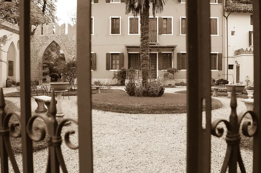
Introduction
Sometimes it seems that the only way to reach our beautiful seaside resorts is to get into a slow queue of cars, amidst the noise and exhaust fumes, but the invitation is different: to enjoy not only the destination, but also the journey. The network of canals, the unmistakable shapes of the drainage pumps that dot the reclaimed lands, the geometry of the cultivated fields, the curious altitude of the land which means that the countryside is sometimes well below the level of the watercourses that crossing it, the system of hedges and embankments, the same relics of the old rural buildings, are some of the sights offered to the visitor who approaches them with patience and respect. From this perspective, the arrival at the wide horizons of the sea has even more the flavor of a discovery: and it is good to remember that, if during the summer the liveliness of the bathing season is attractive and almost irresistible, enjoying the sea has no less charm and pine forest in the winter months, when the silence and quiet promise a different, but no less intense pleasure, and nature and the specimens of wild fauna still present on our coast regain the upper hand. Everyone... have a good ride!
Description of the Cinto Caomaggiore-Caorle route (km 34)
Our route begins at Villa Bornancini, we turn left onto Via Roma and after 300 meters we turn right onto Via Zamper, follow it for 1.8 km and then turn left onto Via Bandida and continue on Via Maute and Via Villa Summaga which after crossing the SR53 it will become Via San Benedetto, we continue for another 450 meters then we turn left onto Via Montecassini, after another 450 meters we turn right onto Via Noiare, we continue for 850 meters then we turn left onto Via Noiari which after 1 .8 km. Provincial Road 67 Portogruaro Fossa Contarina/SP67, we continue for 1.6 km and we will arrive at Concordia Sagittaria.
We continue straight on SR66 for 200 meters then we continue keeping right on Via I Maggio, we cross the Lemene river and turn right onto Piazza G.Matteotti/SP68 which will become Via Cavanella and after 2.6 km we keep right on Via Frattuzza , after 1.3 km we turn left onto Via Violin which after 2 km will take us to Terre di Bonifica.
We continue on Via Violin for another 1.5 km. then we turn right onto Strada Provinciale Jesolana/SP42, after 1.4 km we turn left onto Strada Durisi and after 1.7 km. before the Lemene river we turn left and walk along the river for 3.9 km. then we cross it on Via S.Gaetano, keep right on Stradone R. Franchetti and after 80 meters we turn left to go to the old village of San Gaetano.
We go back and take the Stradone R. Franchetti on the right, keep right on Str.Riello and continue for 2.4 km. then turn left onto Via Cadore/SP59, continue for 3.5 km. then keep left on Str .New, at the roundabout take the second exit onto Piazza Papa Giovanni and after 150 meters keep left onto Campo Castello/Via Largo Gandolfo, after 50 meters turn right onto Piazza S.Pio X, after 20 meters turn left onto Piazza Vesvovado and after 40 meters we keep right onto Piazza Vescovado and we will arrive at the Bell Tower of the Cathedral of Caorle.
Map
Description of the Cinto Caomaggiore-Brussa route (km 34)
Our route begins at Villa Bornancini, we turn left onto Via Roma and after 300 meters we turn right onto Via Zamper, follow it for 1.8 km and then turn left onto Via Bandida and continue on Via Maute and Via Villa Summaga which after crossing the SR53 it will become Via San Benedetto, we continue for another 450 meters then we turn left onto Via Montecassini, after another 450 meters we turn right onto Via Noiare, we continue for 850 meters then we turn left onto Via Noiari which after 1 .8 km. Provincial Road 67 Portogruaro Fossa Contarina/SP67, we continue for 1.6 km and we will arrive at Concordia Sagittaria.
We continue straight on SR66 for 200 meters then we continue keeping right on Via I Maggio, we cross the Lemene river and turn right onto Piazza G.Matteotti/SP68 which will become Via Cavanella, we continue for 6 km. then we turn left on Strada Provinciale Jesolana, after 350 meters we turn right onto Via Casoni and after 600 meters right again onto Via Braccianti, after 100 meters we turn right onto Via Villaviera, continue for 3.4 km. then we turn right onto Via Sindacale and after 500 meters we turn left onto Via Villaviera, continue for 700 meters then turn right onto Strada Alberoni, after 1.5 km. at the crossroads we turn left, continue for 1.4 km. then we turn right onto Via Brussa which after 700 meters becomes Provincial Road Portogruaro Brussa, we continue for 4 km. then we keep left to remain on the provincial road, we continue for another 2.2 km. then we turn right and after 450 meters we turn right again, continue for 150 meters and we will find ourselves on the Brussa beach.
Map
Description of the Cinto Caomaggiore-Bibione route (km 39)
Our journey begins from Villa Bornancini. we turn left onto Via Umberto Grandis SP78 and continue on SP28, take the first road on the right after the junction with the A28 motorway and continue for 2 km. then we turn left onto Via Giovanni Pascoli, after 600 meters we turn right onto Via IV Novembre/SP76 and immediately left onto Via S.da Ronci, we continue for another 2.4 km. then we turn right onto Via Frassinedo and after 70 meters left onto Via Boldara, we continue for 500 meters and turn right onto Via Trieste, we continue for 850 meters and turn right onto Strada Regionale 463, take the first road on the left, Via Teglio and after 130 meters left onto Via Udine/SP93 for 10 meters then turn right onto Via Portogruaro/SP91, continue towards 500 meters and we turn right onto Via Edmondo De Amicis, after 1.2 km. at the roundabout we take the second exit onto Via Silvio Pellico and after 400 meters we keep left onto Via Carlo Altoviti/SP73, after 250 meters we take the first road right then the first left and then left again onto Via Carnielli Don Candido which will become Via Giuseppe Barbuio and then at the crossroads we turn right onto Via Pio X, right onto Via Leonardo Zannier/SP92, left onto Via Camillo Benso Conte of Cavour turn right again to stay on the street and then left onto Via Daniele Manin, continue for 400 meters and turn right onto Via San Marco which will become Via Aldo Moro, continue until the roundabout where we will take the third exit onto SS14, at the roundabout we go straight on SS14 and take the first road on the right, continue for 3.5 km and continue on Via Taglio, at the end of the road we turn left onto Strada Provinciale Jesolana, after 600 meters we turn right onto Via Musili and after 950 meters left on Via Armentarezza, continue for 650 meters then turn right onto Via A.Moro/SP74, at the second roundabout take the first exit onto Via Marinella, continue for 2.4 km. then turn right onto Via S.Falcomer/ SP74, we continue for 3.8 km and at the roundabout we take the second exit onto Via Pineda/SP74, after 1.5 km at the roundabout we continue straight on Corso del Sole, after 750 meters we turn right onto Via Argo and after 250 meters to the left on Via Andromeda, we continue for 1 km. then we turn left and we will reach the Bibione Lungomare Cycle Path.
Map
Reclamation lands
 The “Pianura Veneta tra Livenza e Tagliamento” reclamation consortium is a vast area bordered to the east and west by the two rivers of the same name. It is also characterized by a dense network of natural and artificial canals, which deeply and characteristically mark the agricultural landscape.
Precisely due to the particular altitude of the land, these canals, in their terminal part, are no longer able to naturally receive the load of water, and therefore proceed towards the mouth channeled between the banks. The banks themselves constitute a place well known and loved in local traditions, a destination for fishermen as well as for spring excursions.
Particularly significant and easily recognizable thanks to their peculiar architectural details then appear the buildings of the water pumps, whose construction dates back to the 1920s and 1930s (to find out more: www.pianuraveneta.it).
If in all the buildings it is easy to observe the complex of pumps and locks that regulate the water, it is interesting to note near the Union water pump, in Via Canalon, the phenomenon described above: here in fact the level of the fields, at its lowest point , is visibly lower than the flow line of the watercourse. We invite you to grasp this, like other details, not from the window of a car or from the saddle of a scooter, but from the top of the seat of a bicycle!
Concordia Saggittaria
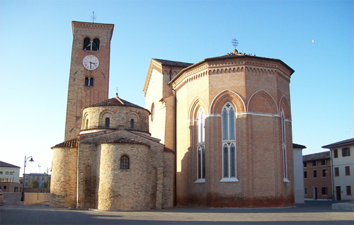 The first settlement in the Concordia area can be traced back to the period between the 9th and 8th centuries BC; however, the history of the town was profoundly marked by the Roman occupation between 40 and 42 BC. It was the emperor Octavian Augustus who founded the colony Iulia Concordia, with the dual purpose of creating a military outpost that defended the north-eastern borders of the Empire, while accommodating the veterans of his army. Concordia therefore became an important reality, with its own theatre, temples, burial grounds, fortifications, roads (the famous Via Annia) and river and lagoon routes. Numerous finds dating back to this era can still be admired in the city's archaeological sites. Involved in the barbarian invasions starting from the 3rd century AD, it played an active role within the empire: the factory of arrows, sagittae, from which the name "Sagittaria" derives, dates back to this period. Starting from 452 it was invaded by Attila's Huns, Lombards and Franks: only the church remained the guardian of culture and traditions. The current cathedral of S. Stefano, dating back to the 11th century, stands on the ruins of two previous basilicas. Flourishing in the Renaissance era, however, starting from the 17th century, it saw a long phenomenon of depopulation and impoverishment, due to the unhealthiness of the area, dotted with large marshy areas and marshes. Only the reclamation interventions, which began towards the middle of the last century, brought about a general recovery for the life of the city. This important achievement is still remembered today by the statue placed in front of the town hall, depicting a "scariolante", affectionately known by the population as "Toni dell'aga".
Caorle
 The ancient urban center of Caorle dates back at least two thousand years, as numerous archaeological discoveries attest.
Entering the city, the first thing you notice is the picturesque fishing port which is still very active, whose tradition happily coexists with the modern tourist vocation of this seaside centre.
Nowadays, the city presents its compact historic center with a characteristic Venetian imprint, with calli, campielli, campi and pastel-coloured houses, almost unchanged. The nucleus of the historic center arose in past centuries around the Romanesque Cathedral, dedicated to St. Stephen, whose foundation is traced back by documents to 1038. Later, in 1080, the cylindrical bell tower was added, one of the symbols of the city.
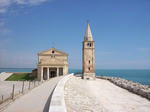
Equally dear to popular devotion is the small church of the Madonna dell'Angelo, located on the rocks, right in front of the sea. The Sanctuary, rebuilt in 1751, recalls the miraculous discovery in the sea, on a marble throne, of an image of the Madonna dell'Angelo, protector of the city's fishing community.
The beach, which stretches for a length of 18 km, is divided into two parts by the mouth of the Livenza river, and in the summer offers numerous opportunities for sport, entertainment and rest. From the top of the access bridge to the city, you can see on the right side the unmistakable complex of the old "borgo Sansonessa", with its characteristic brick buildings.
San Gaetano
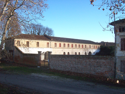 The old village of San Gaetano, close to the Caorle lagoon, has remained almost unchanged since its foundation. The residential area is dominated by the Palazzo dei Nobili Franchetti; equally interesting are the old houses and warehouses of the complex, with recognizable architectural characteristics. The place is also famous from a literary point of view, as the American writer Ernest Hemingway stayed there for some periods, as a guest of his friend Nanuk Franchetti and a great enthusiast of "barrel" hunting, typical of these valleys. It is thought that the landscapes around the village inspired the writer some of the settings in his book Beyond the River and Among the Trees.
Brussa
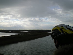 Leaving the water pump behind in the Bacino Villa area, you quickly reach the small town of Brussa. Here, crossing the bridge that crosses the Cavanella Canal, the fascinating landscape of the lagoon oasis of Vallevecchia, located between the Tagliamento and Livenza rivers, appears before your eyes. The latter constitutes a precious example of a sandy coastal territory, whose peculiarities have remained substantially intact, despite the reclamation works. Marine, lagoon and river waters meet here, helping to create a very interesting ecosystem from an ecological point of view. Historically, the marshes present in this place saw reclamation work carried out in the period between the 1930s and the 1960s. The beginning of the creation of the predominantly Pinus pinea pine forest also dates back to the period between the two wars, which constitutes a large green spot visible both from the sea and from the access bridge to the oasis.
Since the 1990s, the regional company "Veneto Agricoltura" has started a series of renaturalization and redevelopment works aimed at reconstructing marsh environments, riparian hedges and increasing the woodland area. This important intervention is still underway, and includes, among other things, the opening of the Vallevecchia Environmental Museum which will be inaugurated this year. It will host environmental education activities and will be the starting point for excursions.
Among the most original characteristics of the place is the coexistence between cultivated areas, agricultural hedges and biotopes typical of the sandy dunes with shrubby vegetation, the mixed pine forest, the hygrophilous woods and the freshwater marsh, with the presence of numerous and suggestive ponds, reed beds and lagoon pockets. Its complex environmental mosaic determines a particular naturalistic richness; this variety of environments therefore constitutes a precious find of biodiversity.
From a faunal point of view, the oasis presents equally interesting aspects. In addition to specimens of freshwater, lagoon and brackish water fauna, such as molluscs, crustaceans and fish typical of the three ecosystems, and numerous communities of insects, amphibians and reptiles, small and large mammals are hosted including the fox, the marten, the hare and the roe deer. The area is particularly important from an avifaunal point of view: small terraces allow bird-watching enthusiasts to observe the many resident and passing birds including various birds of prey, herons, teals, pheasants, little grebes and numerous other species. Precisely due to the presence of this interesting variety of habitats, Vallevecchia has been recognized by the European Community as a Special Protection Area and a Site of Community Importance.
Bibione
 Bibione is a beautiful seaside town on the Adriatic coast, developed between the Port of Baseleghe and the mouth of the Tagliamento river. Since the 1920s, the area has been the subject of a vast and important reclamation work.
It is still possible, in certain areas, to observe the presence of patches of the huge pine forest that in the past characterized the entire area.
The vast beach, 8 km long and up to 400 m wide in some places, is undoubtedly one of the best-known features of this location, even abroad; its depth makes it possible, in addition to bathing, numerous sporting and recreational activities. It is considered particularly appropriate to point out the interesting cycle path that allows you to travel along the beach in its entire length, allowing the visitor to enjoy the view of the sea and move around safely.
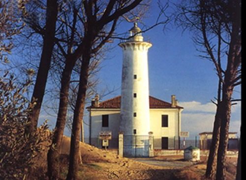
At the extreme western edge of the lagoon, in front of the Baseleghe Port, the traditional "casoni" are still visible today, typical constructions of wood and marsh reeds characteristic of this valley environment, still used today by fishermen in particular fishing periods. The characteristic construction of the lighthouse, dating back to the early twentieth century, is visible as you approach the mouth of the Tagliamento river along the beach. Located on the edge of a beautiful pine forest which can also be explored thanks to a nature trail, it has seen the birth in its vicinity, in recent years, of an attempt to "renaturalise" the beach. A signposted route guides the visitor among the newly formed dunes, underlining the particular characteristics of flora and fauna typical of this natural environment.
Download the Routes
Link to the Cinto Caomaggiore - Caorle route
Download the GPX file for the navigator
Link to the Cinto Caomaggiore - Brussa route
Download the GPX file for the navigator
Link to the Cinto Caomaggiore - Bibione route