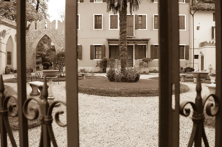
Introduction
It is a route that combines environmental and historical aspects, since this richness has meant that villages, castles and churches have arisen in these places since ancient times. Thus from Portogruaro, crossed by the Lemene, passing through Gorgo, Fratta and Cordovado, with their historical memories, you reach the Venchiaredo fountain and the resurgence area, where streams, meadows, springs and old mills mix with the settlements. And then Sesto al Reghena with its abbey, and Torrate where the water from the springs is conveyed into the aqueduct, to then return to Summaga, with the other abbey.
Discovering where our water comes from, that of the rivers and that of the taps, how fresh and clear it is when it flows, what short route it takes to reach our homes, was a surprise for our students, we hope it will also be a surprise for those will want to try their hand at this path.
Everyone... have a good ride!
Description of the route (km 45)
Our route begins at Villa Bornancini, we turn left onto Via Roma and after 300 meters we turn right onto Via Zamper, we follow it for 1.8 km. then we turn left onto Via Bandida and follow Via Maute and Via di Summaga for 300 meters, we turn left onto Via San Benedetto then right onto Via Villa di Summaga and then right again onto Via San Benedetto, after 170 meters we turn left onto Via Richerio which will take us to Abbey of Santa Maria Maggiore.
We return to Via Richerio and continue until the crossroads, turning left onto Via Montecassino, we follow it for 900 meters and then turn left onto Via Masata, at the roundabout we take the second exit onto Viale Treviso and after 1 km we turn right onto Viale Luigi Cadorna then we turn left remaining on the avenue, after 30 meters we turn right and continue for 300 meters then we turn right onto Via Tarantino, after 70 meters we turn left onto Viale Luigi Cadorna and after 120 meters on the right remaining on the avenue, we pass the roundabout keeping to the right and we turn left onto Via Giuseppe Mazzini/La Stretta, we cross the Giardinetti and continue for 130 meters then we turn left towards Via Molini which will take us to the Mulini di Portogruaro.
We continue on Via Molini then turn right onto Calle Stretta then left onto Corso Martiri della Libertà and after 300 meters we turn right onto Via Silvio Pellico, we follow the street for 500 meters then we turn left onto Viale Isonzo, after 300 meters we take Via Giovanni Battista Vico and after 200 meters we turn right onto Via Girolamo Savonarola, after 250 meters we turn left onto Via Ronchi which we follow for 1.5 km until the fork on the right onto Via del Pascolo and continue on Via Fossalato SP73 until the arrival in Gorgo Borgo Antico.
We continue on Via Carlo Altoviti/SP73 for 700 meters then we turn right onto Via Castello here we will find Fratta.
We go back and go straight on SP91/Via I.Nievo for 1.8 km. then we turn right onto Via Chiesa and continue on Via Suzzolins until the crossroads on the right with Via Teglio/SP18 which we will follow for 1.3 km. then we will turn turn right onto Piazza Duomo and after 50 meters we will find the Duomo Antico.
We continue on Piazza Duomo and Piazza al Tiglio continuing on Via Duomo and Via Castello which will take us to Cordovado.
We continue on Via Castello and turn right onto Strada Regionale 463, at the roundabout we take the third exit onto Viale della Stazione, after 300 meters we turn left remaining on Viale della Stazione then we turn right onto Via Venchiaredo, we continue for 500 meters and at at the crossroads we turn left remaining on Via Venchiaredo which will take us to the Venchiaredo Fountain.
We continue on Via Venchiaredo and after 150 meters we turn left onto Via Stalis and after 630 meters we will find the Church of San Pietro on our right.
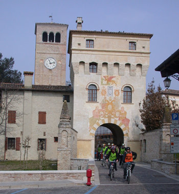
We continue on Via Stalis and at the crossroads we turn left onto Via Piave at the next crossroads we turn right onto Via Levada/SP16, at the roundabout we take the second exit onto Via Zanardini and after 280 meters we turn right onto Via Roma, after 200 meters we will turn right onto Piazza Castello and we will enter Sesto al Reghena.
We go back to the crossroads and turn right onto Piazza Cardinale Barbo and continue on Via Giotto di Bondone, continue for 1.4 km. then we turn right onto Via Marignana continuing on Viale Stazione and Via Braidacurti, after 3.5 km then we turn right on Via Udine/SP1 (bike in hand), take the first street on the left then the first on the right and we will arrive in Torrate.
We go back to the crossroads and turn right then left and left again, at the crossroads we turn right onto Via Udine/SP1 and after a few meters we turn left onto Via Braidacurti/SP42, we continue for 6 km on SP42 then we turn left on Via del Palu and continue on the cycle/pedestrian path after 500 meters we keep right on the cycle/pedestrian path then left and left again on the Lungo Mulino cycle/pedestrian path, at the end of the path we turn right onto Via Umberto Grandis/SP78 and at the crossroads right onto Via Roma , we returned to Villa Bornancini.
Abbey of Santa Maria Maggiore - Summaga
 Near the Reghena river, a tributary of the Lemene river, three kilometers from Portogruaro, stands the Benedictine abbey of Summaga; once again the reference to water is immediate in the Latin name "Summa aqua", which here however is thought to indicate marshy land, invaded by water and made inhabitable by the monks.
The original structure dates back to the 10th-11th centuries; it was built on the initiative of the Bishops of Concordia, while the current one, with three naves, dates back to the early 13th century. The ancient chapel, located at the base of the bell tower, appears to pre-exist the abbey church itself; however, there are no longer any traces of the monastery. Two series of particularly valuable frescoes characterize the interior: those of the 11th century chapel and those of the central apse, from the 13th century, the latter attributable to thirteenth century Friulian painting. In the following centuries the structure underwent numerous renovations which did not alter its sober harmony. Following the restorations carried out in various phases throughout the 20th century, the Summaga Abbey has now regained its original 13th-century appearance.
Portogruaro
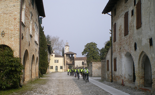
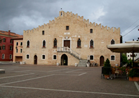 A walk under the arcades of the historic center of Portogruaro, among buildings and canals, brings out the medieval urban layout that is still almost intact. In fact, the city arose as a river port in the Middle Ages and is structured like a comb along two streets parallel to the banks of the Lemene river. Portogruaro MillThe most characteristic building of the medieval period is the Gothic Town Hall (1265 – 1512), with a sloping façade with Ghibelline battlements and Gothic windows, which dominates the spacious square, the heart of all the commercial cities in the Italy of the Municipalities ( today Piazza della Repubblica). PortogruaroNear the Cathedral there is one of the most evocative corners of the city: the Mills which date back to the 12th century and the Fish Market with its small wooden oratory from the first half of the 1600s. The city was closed by a wall and was accessed through five gates, three of which still exist, and the banks were joined by 4 bridges. Under Venetian rule the city was enriched and embellished architecturally in the 15th-17th centuries. It can be observed that the buildings on the two main streets have Gothic characteristics on the ground floor and Renaissance ones on the upper floor, thus clearly demonstrating why Portogruaro is defined as a city suspended between the Middle Ages and the Renaissance.
Gorgo "Borgo Antico" and Fratta
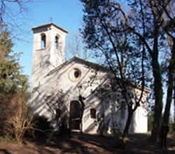 Our first stop is in Gorgo “Borgo Antico”, one of the oldest inhabited centers in the municipality of Fossalta di Portogruaro; In Roman times, a branch of the Tagliamento river passed through this place, defined in medieval chronicles as "ferox et rapax", precisely because of the sudden and violent fury of its floods. Probably for this reason, the name of Gorgo was given to the locality. The first document that testifies to its ancient existence is a papal bull of 1186. Here is the church of Santa Cristina, from the 12th-13th century, built on a previous structure, surrounded by greenery and inserted in a suggestive grove; owned by the Municipality, recently restored. Continuing for a kilometer you reach Cortino di Fratta, a recently restored rural manor house, with its beautiful park, now home to the museum dedicated to the writer Ippolito Nievo, who set his novel The Confessions of an Italian in these places. Cortino di FrattaCortino is also a multipurpose cultural center and several archaeological finds from the castle are kept there. The castle of Fratta was built by the bishops of Concordia before 1050; the first news regarding a fortification in Fratta dates back to 1186. Located in a place not far from the main communication routes, it probably arose due to the need to defend itself from the invasions that threatened the Friulian and Venetian plains in that period. Today there are few traces, archaeological finds and documents left of the castle, but no sign of the structure.
Cordovado
 The toponym Cordovado derives from the Latin words curtis (court) and vadum (ford) and, in medieval times, named an agricultural complex located near the ford on an ancient branch of the Tagliamento river. By will of the bishops of Concordia, owners of these lands, it was built as a fortification between the 11th and 12th centuries to defend the territory from barbarian invasions. Cordovado thus became an important castle-city protected by walls, a moat with a drawbridge and two gate towers which are still well preserved today. The castle area, where medieval traces are concentrated, is now occupied by buildings from later periods: Palazzo Freschi-Piccolomini, Palazzo Bozza-Marrubini, Palazzo Agricola. Next to the north tower of the ancient village, there is the ancient church of San Girolamo in Castello. Just before reaching the medieval village there is the Ancient Cathedral of Sant'Andrea, a church mentioned in the 1186 bull of Pope Urban III, originally consisting of a single nave; the two side naves were built in the 16th century. Inside there are interesting altarpieces and precious frescoes. Cordovado, as indicated on a sign at the beginning of the town, was annexed to the "The most beautiful villages in Italy" club in December 2004.
Venchiaredo Fountain - Sesto al Reghena
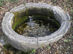 After passing the level crossing, near the Cordovado railway station, you enter the municipality of Sesto al Reghena, in a place that has recently been the subject of environmental restoration. The signs indicate the place as the “IPPOLITO NIEVO” Literary Park. Here, immersed in the greenery of a grove on the border between Cordovado, Sesto al Reghena and Gruaro, there is a water source that gives rise to a stream, it is the Venchiaredo Fountain. The place is thus described in the fourth chapter of Ippolito Nievo's work.
“Confessions of an Italian”:
"Between Cordovado and Venchieredo, a mile from the two towns, there is a large and clear fountain which is also said to contain many refreshing and healthy qualities in its water. But the nymph of the fountain did not believe in relying solely on the virtues of the water to entice devotees and she surrounded herself with such a beautiful horizon of meadows and woods and sky, and with such a hospitable shade of alders and willow trees. which is in truth a recess worthy of Virgil's brush where she pleased to place her room. fountain of VenchiaredoSientiehidden and meandering roles, whisper of rivulets, sweet and mossy slopes, nothing is missing all around it".
The text is reproduced in a stone, placed next to the source. The place is still very suggestive, and despite the years that have passed and the changes that have occurred, you can still feel the air of rural peace that inspired the writer.
Mills of Stalis - Gruaro
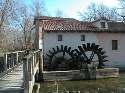 It is a milling complex of medieval origin that is encountered along our itinerary, as soon as we enter the territory of the Municipality of Gruaro. It owes its name to the presence of stables (lat. Stabulis) in the area. These are two mills on the Lemene river, the oldest is mentioned for the first time in documents from 1432, while the most recent dates back to the end of the 19th century. The complex was linked to the Abbey of Sesto al Reghena, but its location along the route that connected it to Cordovado made it part of the economic and social life of both villages and other nearby villages. mills of Stalis Since the fifteenth century, both the cereal mill and the wood saw and pestles for beating the flax fibers have been working inside it. From the seventeenth century onwards the property passed to the Tasca family from Portogruaro; a century later, wool fulling and barley husking were added to the already existing activities. It remained in operation until the 1970s. The current appearance has been modified compared to the original, both due to the demolition of some buildings and the changes in the flow of the water which led to the disappearance of some river islands. The mill today is home to a small exhibition of machinery dating back to the 1920s; furthermore, one of the wheels was recently put back into operation.
The force of the water which once turned even six wheels is still clearly visible and the surrounding landscape is also worth a visit, characterized by the presence of closed fields, typical of the Friulian tradition, which, together with the canal which is encountered upon arriving, with the Its crystal clear waters and white gravel bottom make dei Mulini and its surroundings a particularly evocative naturalistic place.
Church of San Pietro - Bagnarola
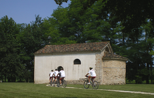 The architectural layout, in Romanesque style, consists of a rectangular hall and a semicircular apse with a lowered arch opening.
The old masonry is made up of heterogeneous recycled material, such as brick from the Roman era, arranged in a 'herringbone' pattern. Over the centuries the building has undergone various alterations, most evident on the facade wall; even the original bell tower has disappeared, now replaced by an iron bell tower.
Around 1960, neglect and then abandonment reduced the church to the state of ruins. A local group that arose spontaneously took charge of the restoration. On 29 June 1997, the completely restored church was returned to its community and reopened for worship.
The archaeological investigation carried out during the works highlighted the remains of some burials from the 12th - 15th centuries. and two floor layers. Of the frescoes, from different periods, only a fifteenth-century fresco remains with the Virgin, the Child and St. Sebastian.
Sesto al Reghena
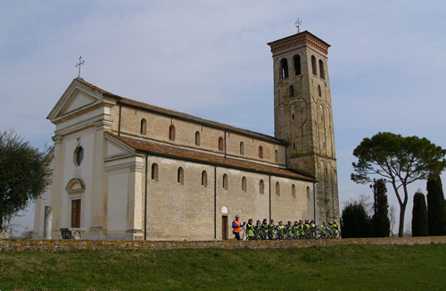
 Sesto al Reghena is one with the Benedictine Abbey of Santa Maria in Sylvis and together they constitute the most important historical site in this route, since, despite being of ancient foundation and already important in Roman and Lombard times, Sesto al Reghena was in In the Middle Ages, Sesto experienced its period of greatest splendor with the annexation of the Abbey and its territories to the feudal dominion of the Patriarchate of Aquileia. The Abbey, so called because it was then immersed in an extensive forest, was founded in the year 741; in 762 it received the donation of three Lombard nobles Erfo, Marco and Anto which was followed by numerous others. Over the years its power increased not only on a religious level, but also on a civil level, so much so that it took on the appearance of a medieval castle with its defensive system made up of towers and moats. From the 11th to the 14th century, 50 villas and castles located in Friuli, in the territories of Treviso, Verona, Vicenza, Belluno, Ancona, Trieste and in Istria depended on it. Following the annexation to the Venetian republic there was a progressive decline which made the place marginal, but at the same time preserved its original character which can still be seen when visiting the village.
Torrate - Chions
 The medieval village
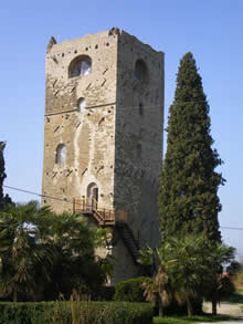
The tower from which the town takes its name, in the municipality of Chions, is the only survivor of one of the oldest castles in Friuli, belonging to the ancient and powerful family of the Lords of Sbrojavacca, vassals of the Patriarch of Aquileia and the abbots of Sixth. The ancient castle was attacked several times, remodeled and reinforced, changing its appearance, the last time at the beginning of the 19th century to become a residential building. For unknown reasons it was demolished in 1820. Sbrojavacca Near the tower there is the church of S. Giuliano which was incorporated into the castle complex. The current church was built in 1332, then rebuilt in 1661.
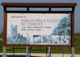 The Fonti di Torrate park
The Torrate di Chions Fonti Park is so called because it contains, within its 80 hectares, equipped with 4 kilometers of cycle paths, 22 drinking water wells. The park was founded in 2003, after the Aqueduct decided to purchase all the land around the wells with the aim of preserving the wells themselves from possible pollution resulting from pesticides or fertilizers. It immediately became clear that this was a precious but degraded area; the ancient lowland forest that completely covered it had been cut down around 1970 (only about seven hectares remain to the north of the park), the canals and waterways were covered with brambles and clogged with parasitic vegetation. The aqueduct has therefore decided to start a process of ecosystem protection and environmental restoration. In collaboration with the Faculty of Agriculture of the University of Padua, and after having recovered the spontaneous vegetation present, ABL planted the first 25,000 native tree plants (oaks, hornbeams, alders, elms) with the aim of reconstructing the ancient forest with suitable essences. Wetlands have been created with the presence of ponds fed by groundwater. in the Torrate spring park, a photovoltaic system was built for the production of 20 KW electricity, used in raising water. The old mechanical workshops have been transformed into a modern multifunctional environmental education room. Another consequence of the creation of the Park was the immediate repopulation of the area which became a safe refuge for many species of animals. Slowly the Park is becoming a center of attention for a plurality of interests.
Map